This article aims to inform the public and should not replace the advice of a Chartered Structural Engineer or Geotechnical Engineer.
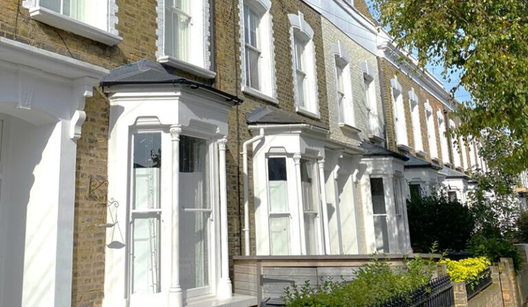
When purchasing a property in Greater London, contacting the Local Authority as part of your searches will provide guidance on the risks of subsidence, landslip, and heave. This information is based on statistical factors such as local geology and insurance company data on subsidence claims in your postcode.
Subsidence claims are most frequent where London Clay is near the ground surface and large mature trees are nearby. Consequently, the risk to a specific property depends on various factors, though some general tips and guidance can be offered.
While this advice is intended to inform, it is not meant to alarm potential buyers or sellers or suggest that all properties in a particular London area, town, or postcode are affected by these risks. On the contrary, due to proactive measures by most Local Authorities to maintain trees, these risks have decreased in recent years.
The following general guidance may be of interest:
1. Geological Map of London, the South East, and the UK
The British Geological Society (BGS) offers a free website and app that provides likely geological details for any postcode. This resource needs careful use but can help establish whether a property is located on clay soil.
The map uses two distinct layers to show the deep underlying bedrock, i.e. the soil very deep below the ground, together with the superficial geology which is the most important soil type as this is closest to ground level. This is likely to be the soil type found immediately below most foundations in period houses built before the war and even before 1976.
If no superficial geology information is recorded for a postcode, this indicates that the surface geology is the same as the bedrock – generally London Clay in most of Greater London, or chalk near the North Downs in Surrey, for example.
General soil types and associated risks:
– London Clay: High risk of subsidence especially with large nearby trees.
– Head: Intermediate risk with nearby trees.
– Alluvium: Soft soil with a risk of historic settlement.
– Langley Silts: Clay with silt.
– Gravel Soils (e.g. Kempton Park, Taplow, Lynch Hill, Hackney) – Generally more strong and stable than clays and other soils listed above.
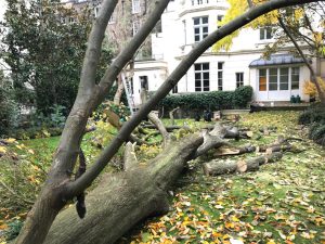 2. Trees
Most significant subsidence cases on clay soils involve trees or mature shrubs. The risk of subsidence depends on the location and size of the tree if the superficial or outcropping bedrock is clay-based. Conversely, stable soils like sand, gravel, or chalk reduce this risk. However, large trees can disrupt drains, potentially leading to subsidence due to soil softening or erosion.
Useful guidance regarding trees:
a) Consider the proximity of the tree to the house. If a tree’s height exceeds its distance from the house, root systems likely extend beneath the property.
b) Determine if the tree is within your control (i.e. within your property boundary) or on neighbouring or local authority land.
c) Check if the tree is protected by a preservation order or if the property is within a conservation area, requiring local authority approval for any alterations.
d) If a tree is suspected to cause subsidence damage, the tree owner may need proof, such as soil and root testing, to address the issue.
3. Drainage Issues and Loose Soils
Period houses often rest on manmade materials known as fill, covering London’s natural geology, whether gravels or clays. As a general guide, if loose soils are near the surface and below the house foundations, softening and erosion may occur, especially with poorly maintained drains located beneath or adjacent to the house. Subsidence can result from drains even when sands and gravels are close to the surface, not just clay soils. Given that drain surveys are relatively inexpensive, it is prudent to include these in early maintenance plans when purchasing a property. Requests to test drains pre-purchase can delay transactions, with some vendors reluctant to undertake such testing. Fortunately, drainage repairs are typically affordable, often costing a few thousand pounds rather than tens of thousands.
4. Foundation Depths
Subsidence risk is heavily influenced by foundation depth. Shallow foundations are more susceptible to soil drying out and shrinking during summer, tree root intrusion, and proximity to drains. Deeper foundations are generally more stable, with reduced susceptibility to seasonal soil volume changes and tree root impact. Modern properties typically feature deeper and more robust foundations, especially following the design improvements post-1976 after the significant summer drought.
Houses with cellars benefit from naturally deeper and more stable foundations. Houses with lower ground floors are usually better protected by having most of the property and foundations significantly below street level where trees are located. This might not apply to trees in rear gardens, however, where the external ground level is often close to lower ground floor level.
Foundation Depth Guide:
– Pre-1920: 30 cm to 45 cm
– 1920-1930s: 45 cm to 60 cm
– 1950-1975: 60 cm to 1 m
– Post-1976: 1 m or deeper
5. Building Regulations Approved or Engineer-Designed Foundations
Modern foundations are generally more robust, particularly if approved by the Local Authority Building Control Department or designed by a Chartered Structural or Civil Engineer based on soil testing and considering the mature height of nearby trees.
Note: that self-contained conservatories with external doors to the main house often do not comply with Building Regulations.
Local Authority approvals are based on current site conditions, not future tree heights, and the Authority holds no design liability. Therefore, consulting a reputable firm of chartered Structural Engineers for foundation designs of extensions and new constructions is advisable.
The National House Building Council (NHBC) offers extensive guidance to designers and developers for building near trees on clay soils, ![]() considering the soil’s shrinkage characteristics determined by testing or assumed worst-case scenarios. Tall trees, such as large oaks, London Planes, and Poplars, can necessitate foundation depths or underpinning up to 3.5 meters.
considering the soil’s shrinkage characteristics determined by testing or assumed worst-case scenarios. Tall trees, such as large oaks, London Planes, and Poplars, can necessitate foundation depths or underpinning up to 3.5 meters.
For new foundations exceeding about 2 meters, alternative methods like bored piles, concrete stilts drilled deep into the ground with a reinforced slab or a series of linking beams on top, are often more economical and practical.
Conclusions
This article serves as a general overview and should not be used in isolation without obtaining location-specific advice from relevant professionals, such as a local chartered structural engineer. It aims to provide valuable insights for property owners and non-engineering professionals, including solicitors, general practice surveyors, and estate agents, on broad geological and structural matters.
The paper introduces the geology of the London area and provides guidance on how to use the British Geology viewer map or app to identify the most likely soil type for a specific address or postcode. It explains the distinction between bedrock and superficial geology, as well as the differences between clay soils and gravel/sandy soils. Guidance is also provided on typical foundation depths for buildings of different ages.
This article highlights the importance of considering trees on clay-based soil, and the potential mature height of a tree if it isn’t controlled. This is crucial when designing foundations for extensions or new buildings. While it aims to be informative, we recommended you consult with a chartered structural engineer for more specific advice.


